Showing posts with label maps. Show all posts

Monday, January 6, 2020

Travel databases

We have databases that are perfect for travel! They are: Mango Languages, Global Road Warrior, and A-Z Maps Online. FYI: You will need to sign in with your NTNET username and password to access them. You can find them all at our Databases A-Z page. The link to this page is on our home page. Please keep in mind that these databases display the best and are the most usable on a desktop, laptop, or tablet computer. However, they have mobile-responsive sites, which can be used on your smartphone.

Mango Languages has over 70 languages for you to learn.  There are audio and video portions and even an app. You can create an account to track your improvement or be a guest user. This is also a great way for English as a Second Language learners to brush up on their language skills.

Screenshot of an Italian video lesson.


Global Road Warrior is designed for business travelers but it  can be used by anyone.  It has very comprehensive information on a slew of countries. This information includes tips on society, culture, internet access, politics, etiquette, and much, much more.

A screenshot of information about Japan.


A-Z Maps Online. This has an amazing amount of different types of maps from all around the world. A few of the map types include: empire, holy land, climate, ecology, geology, NASA, city, world and USA. Below is a 1595 map of the world.

A 1595 world map from A-Z Maps Online

Happy travels!

Tuesday, July 31, 2018

The Living New Deal

The Living New Deal is a non-profit organization that exists to document all of the public works that were created by various New Deal programs from 1933-43. Several professors at the University of California-Berkeley began this project in 2005 by gathering information on New Deal public works projects in California. In 2010, they expanded and began documenting projects nationally. The New Deal refers to a wide range of economic programs that President Franklin Roosevelt's administration enacted in response to the Great Depression


The Living New Deal's website contains a wealth of information and resources. My favorite tool is the map. You can use navigation tools in the map to either zoom in or search for a specific location in the United States and see New Deal public works projects in the area. 
Map from the Living New Deal website.
Each red dot represents a public works project built by a New Deal program between 1933-43. 
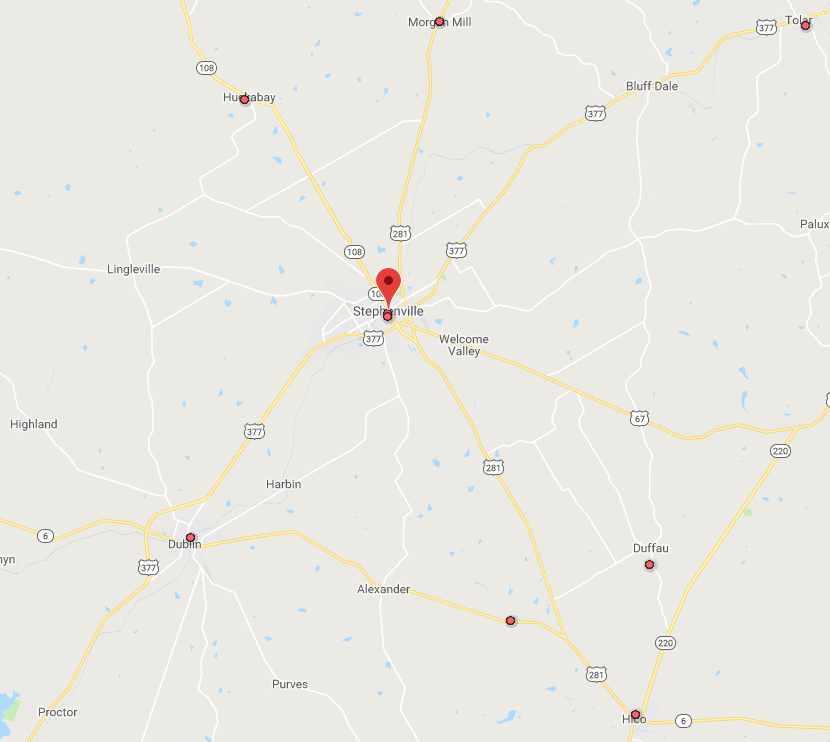
Close up view of Stephenville and surrounding towns reveals several New Deal projects in the area.  
This map reveals that there are two buildings in Stephenville that were built by New Deal programs. One is the current Public Library and former post office building located at 174 N. Columbia Street. It was funded by the US Treasury Department and completed in 1935.

Current Stephenville Public Library and former post office.
The building was a New Deal public works project completed in 1935.
Michael Barera [CC BY-SA 4.0  (https://creativecommons.org/licenses/by-sa/4.0), from Wikimedia Commons.

The other is the Recreation Hall located at 378 W. Long Street. It was built the Works Progress Administration (WPA) and completed in 1938. Today it houses the offices of the Stephenville's Parks and Recreation Department.

Recreation Hall in Stephenville. Built by the WPA in 1938.
Joshua Wallace - Photographer & Copyright Holder, 2018. 
If you want to learn more about the New Deal, the Dick Smith library has a large collection of items on the subject. Such as these titles:

Digital Film:
A Chaos of Experimentation

Books & eBooks:
A Concise History of the New Deal by Jason Scott Smith
The Crash of '29 and the New Deal by Bruce Glassman
Designing a New America: The Origins of New Deal Planning, 1890-1943 by Patrick D. Reagan


Contact us at 254-968-9249 or reference@tarleton.edu if you have any questions about library resources on the New Deal or any other topic.


Tuesday, June 5, 2018

Texas Traveling

Are you planning a trip somewhere in Texas this summer? If so, then make a stop by the library before you do. We have a wealth of travel information available in our collection.
The Alamo, San Antonio, TX 2009.
By Daniel Schwen [CC BY-SA 4.0 (https://creativecommons.org/licenses/by-sa/4.0)], from Wikimedia Commons.
Periodicals 

  • Texas Highways - magazine published monthly by the Texas Department of Transportation. Contains many articles with Texas road trip ideas.
  • Texas Monthly - this magazine covers all things Texas (politics, culture, and much more). It also frequently publishes useful information for Texas travel such as this recent article on traveling in the hill country. 
  • Texas Parks and Wildlife - monthly magazine published by the Texas Department of Parks and Wildlife. Contains useful information on the recreational activities available at Texas state parks.

Books & eBooks
1933 Texas Highway Map.
Probably don't want to use this for current travel purposes.
[Public Domain], from Wikimedia Commons. 
Websites
If you need help finding travel information for Texas or any other destination, then contact the library at reference@tarleton.edu or 254-968-9149. 

Tuesday, July 11, 2017

Drive Texas Map

Are you planning a Texas road trip anytime soon? Then you should definitely check out the online Drive Texas map created by the Texas Department of Transportation. This map provides up-to-date information on Texas road conditions. It's a handy resource to consult before going on any road trip.

Each icon on the map represents a different condition:construction, closed, damaged, accident, etc. 

The map allows users to zoom in to a particular location, or you can search for a specific place with the map's search tool. If you click on an affected roadway, you will be provided with additional information.

Close up view of Stephenville area. 
After clicking on the affected road this information appears. 


The map has tools that allow you to choose what type of condition (i.e. accidents, etc.) you want to see on the map. You can also choose to see future planned construction or closures. There are options that also allow you to see traffic conditions or the locations of rest areas and travel information centers.

Choose to view various types of current and future conditions
Find locations of rest areas and other resources. 


Traffic conditions in the Dallas/Fort Worth area. 

Before you start your next Texas road trip, you should consult some library resources as well.

Here's a few books we have on the topic:
Exploring the Edges of Texas by Walt Davis and Isabel Davis.
History along the Way: Stories beyond the Texas Roadside Markers by Dan K. Utley and Cyntia J. Beeman.
Texas Road Trip: Stories from Across the Great State and a Few Personal Reflections by Bryan Woolley.

Library staff can assist you in finding information resources for your next road trip at reference@tarleton.edu or 254-968-9249.

Thursday, April 13, 2017

The Racial Dot Map

Demographers at the University of Virginia's Weldon Cooper Center for Public Service have created an interactive map that allows users to examine population groupings throughout the United States.

The map's creators used data gathered from the 2010 census to place 308,745,538 dots on a map of the United States. Each dot represents one person counted in that census. The dots are color-coded by race/ethnicity: whites are represented with blue dots, African Americans with green dots, Hispanics with orange dots, and Asians with red dots. People who don't fall under any of the above categories are represented with brown dots.

A view of the lower 48 states.
The map allows users to zoom in to see the demographics of local areas.

A close up view of the Dallas/Fort Worth area. 

Each dot is smaller than a pixel. That makes viewing individual dots in rural areas challenging. The map allows users to turn off the racial color-coding, and every person is then represented with a black dot. This helps to better see people in rural areas.

A close up view of Stephenville, TX with color-coding removed. 
Take some time to explore this fascinating map.


Tuesday, March 21, 2017

Global Road Warrior

Are you planning any international travel in the near future or would you like to learn more about the world? If so, then the library has a great resource for you: Global Road Warrior. It is a database that contains a wealth of information about every country on Earth. You can find it on the library's A to Z Databases List.

There are two ways to find information about a country thorough Global Road Warrior. Either select the name of the country on the alphabetical list, or select it on the interactive map.

Select a country from the list on the left or the map on the right. 
After you choose a country you will then be provided with a wide range of information about it: geography, history, culture, demographics, maps, etc.


If you are planning to travel to the country, then you must check out the Travel Essentials section. It provides valuable information such as: visa requirements, products you are allowed or not allowed to bring into the country, recommended immunizations, etc.

Visa and Passport requirements for travel to India. 

The library has other databases that are also helpful resources for travel such as:
  • A to Z Maps - provides detailed maps of every US state and most countries of the world. 
  • Mango Languages - provides interactive tutorials for 72 languages. 

If you have any questions about Global Road Warrior then email reference@tarleton.edu or call 254-968-9249. 


Click here to find information about study abroad opportunities provided by Tarleton State University. 

Wednesday, October 20, 2010

Strange Maps of Strange Places


Maps have been around for thousands of years, ever since man needed to record the location of places. Some early maps of Pacific Islanders' look like a collection of sticks and seashells. As cartography rose as a science and an art form maps became more detailed and colorful. Today with GIS and Google Maps just about anyone can produce a map of just about anything. Some would argue that the advent of GIS is the death knell of traditional paper maps. I love maps and when one of my librarian friends showed me this blog I just had to share it. Frank Jacobs Strange Maps, Cartographic Curiosities blog is a wonderful blog for those who love cartography. While Frank loves maps your usual atlas does not interest him. To quote from his blog "he collects and comments on all kinds of intriguing maps-real, fictional, and what-if ones..." So if I have aroused your cartographic curiosity click on this link: http://bigthink.com/blogs/strange-maps?page=1

Monday, July 12, 2010

Where Americans Are Moving

That Americans are on the move should not come as a surprise. We are a very mobile society today. Almost from the time of the first settlers, there has been a movement westward. Today we move because of jobs, education, or retirement as examples. The Internal Revenue Service compiled a map using data from 2008 that indicates the number of people that moved from one county to another and their average income. By clicking on a county, the map highlights those counties where there was an exchange of population. For example in 2008 16 people with an average income of $16,200 moved from Eastland County to Erath County and 52 people with an average income of $14,300 moved from Erath County to Eastland County. The map also has buttons for areas such as Seattle, Los Angles, Dallas, Chicago, and Detroit. There a few surprises and a few things that are not surprises. You can explore the map at http://www.forbes.com/2010/06/04/migration-moving-wealthy-interactive-counties-map.html

Monday, June 28, 2010

Today in History - The Library of Congress American Memory

The staff member who was supposed to post in the Library Online Lounge is out today with an injury, and I did not remember this until a half-hour before I'm supposed to go home! Scrambling around for something to post, I Googled "today in history" and came up with this.

The Library of Congress' American Memory website
provides free and open access through the Internet to written and spoken words, sound recordings, still and moving images, prints, maps, and sheet music that document the American experience. It is a digital record of American history and creativity. These materials, from the collections of the Library of Congress and other institutions, chronicle historical events, people, places, and ideas that continue to shape America, serving the public as a resource for education and lifelong learning.
Poke around their collections sometime - there's everything from baseball cards to Coca-Cola TV advertisements to daguerreotype photos; panoramic maps to WPA posters to quilts.

Friday, February 15, 2008

Sometimes the clearest answer is a MAP

Check out
100 Things To Do with Google Maps Mashups - gmapsmania!
This site can help you simulate a flood to show damage effects, see where UFOs have been sighted (not complete: no record for Stephenville when I checked!), find the nearest Starbucks, and best, make your OWN Google maps mashup!! And 96 other Cool Maps...

http://gmapsmania.googlepages.com/100thingstodowithgooglemapsmashups