Showing posts with label websites. Show all posts

Tuesday, July 31, 2018

The Living New Deal

The Living New Deal is a non-profit organization that exists to document all of the public works that were created by various New Deal programs from 1933-43. Several professors at the University of California-Berkeley began this project in 2005 by gathering information on New Deal public works projects in California. In 2010, they expanded and began documenting projects nationally. The New Deal refers to a wide range of economic programs that President Franklin Roosevelt's administration enacted in response to the Great Depression


The Living New Deal's website contains a wealth of information and resources. My favorite tool is the map. You can use navigation tools in the map to either zoom in or search for a specific location in the United States and see New Deal public works projects in the area. 
Map from the Living New Deal website.
Each red dot represents a public works project built by a New Deal program between 1933-43. 
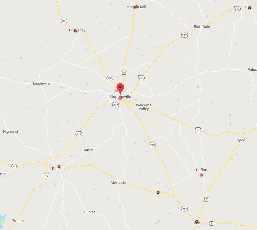
Close up view of Stephenville and surrounding towns reveals several New Deal projects in the area.  
This map reveals that there are two buildings in Stephenville that were built by New Deal programs. One is the current Public Library and former post office building located at 174 N. Columbia Street. It was funded by the US Treasury Department and completed in 1935.

Current Stephenville Public Library and former post office.
The building was a New Deal public works project completed in 1935.
Michael Barera [CC BY-SA 4.0  (https://creativecommons.org/licenses/by-sa/4.0), from Wikimedia Commons.

The other is the Recreation Hall located at 378 W. Long Street. It was built the Works Progress Administration (WPA) and completed in 1938. Today it houses the offices of the Stephenville's Parks and Recreation Department.

Recreation Hall in Stephenville. Built by the WPA in 1938.
Joshua Wallace - Photographer & Copyright Holder, 2018. 
If you want to learn more about the New Deal, the Dick Smith library has a large collection of items on the subject. Such as these titles:

Digital Film:
A Chaos of Experimentation

Books & eBooks:
A Concise History of the New Deal by Jason Scott Smith
The Crash of '29 and the New Deal by Bruce Glassman
Designing a New America: The Origins of New Deal Planning, 1890-1943 by Patrick D. Reagan


Contact us at 254-968-9249 or reference@tarleton.edu if you have any questions about library resources on the New Deal or any other topic.


Tuesday, June 5, 2018

Texas Traveling

Are you planning a trip somewhere in Texas this summer? If so, then make a stop by the library before you do. We have a wealth of travel information available in our collection.
The Alamo, San Antonio, TX 2009.
By Daniel Schwen [CC BY-SA 4.0 (https://creativecommons.org/licenses/by-sa/4.0)], from Wikimedia Commons.
Periodicals 

  • Texas Highways - magazine published monthly by the Texas Department of Transportation. Contains many articles with Texas road trip ideas.
  • Texas Monthly - this magazine covers all things Texas (politics, culture, and much more). It also frequently publishes useful information for Texas travel such as this recent article on traveling in the hill country. 
  • Texas Parks and Wildlife - monthly magazine published by the Texas Department of Parks and Wildlife. Contains useful information on the recreational activities available at Texas state parks.

Books & eBooks
1933 Texas Highway Map.
Probably don't want to use this for current travel purposes.
[Public Domain], from Wikimedia Commons. 
Websites
If you need help finding travel information for Texas or any other destination, then contact the library at reference@tarleton.edu or 254-968-9149. 

Tuesday, July 11, 2017

Drive Texas Map

Are you planning a Texas road trip anytime soon? Then you should definitely check out the online Drive Texas map created by the Texas Department of Transportation. This map provides up-to-date information on Texas road conditions. It's a handy resource to consult before going on any road trip.

Each icon on the map represents a different condition:construction, closed, damaged, accident, etc. 

The map allows users to zoom in to a particular location, or you can search for a specific place with the map's search tool. If you click on an affected roadway, you will be provided with additional information.

Close up view of Stephenville area. 
After clicking on the affected road this information appears. 


The map has tools that allow you to choose what type of condition (i.e. accidents, etc.) you want to see on the map. You can also choose to see future planned construction or closures. There are options that also allow you to see traffic conditions or the locations of rest areas and travel information centers.

Choose to view various types of current and future conditions
Find locations of rest areas and other resources. 


Traffic conditions in the Dallas/Fort Worth area. 

Before you start your next Texas road trip, you should consult some library resources as well.

Here's a few books we have on the topic:
Exploring the Edges of Texas by Walt Davis and Isabel Davis.
History along the Way: Stories beyond the Texas Roadside Markers by Dan K. Utley and Cyntia J. Beeman.
Texas Road Trip: Stories from Across the Great State and a Few Personal Reflections by Bryan Woolley.

Library staff can assist you in finding information resources for your next road trip at reference@tarleton.edu or 254-968-9249.

Thursday, April 13, 2017

The Racial Dot Map

Demographers at the University of Virginia's Weldon Cooper Center for Public Service have created an interactive map that allows users to examine population groupings throughout the United States.

The map's creators used data gathered from the 2010 census to place 308,745,538 dots on a map of the United States. Each dot represents one person counted in that census. The dots are color-coded by race/ethnicity: whites are represented with blue dots, African Americans with green dots, Hispanics with orange dots, and Asians with red dots. People who don't fall under any of the above categories are represented with brown dots.

A view of the lower 48 states.
The map allows users to zoom in to see the demographics of local areas.

A close up view of the Dallas/Fort Worth area. 

Each dot is smaller than a pixel. That makes viewing individual dots in rural areas challenging. The map allows users to turn off the racial color-coding, and every person is then represented with a black dot. This helps to better see people in rural areas.

A close up view of Stephenville, TX with color-coding removed. 
Take some time to explore this fascinating map.


Wednesday, October 2, 2013

Library of Congress temporarily shut down

Because the US Congress failed to pass an appropriations bill on September 30, government offices and services that are deemed nonessential have shut down. Library of Congress buildings are closed to the public, and its website is inaccessible, except for THOMASCongress.gov, and Cataloger’s Desktop. However, the Internet Archive’s Wayback Machine still offers access to LC and other agencies before their websites went dark.

The Tarleton Library is still open, however, so please stop by, call, email us, tweet, or contact us through Facebook if you have any questions or need help locating resources!


Phone: 254.968.9249
Email: reference@tarleton.edu
Facebook
Twitter

Thursday, September 19, 2013

Web Resources by Subject at your fingertips

The library homepage is the gateway to so many useful resources and information. Although we provide subject guides for several topics we also have pulled together a variety of web resources lists (also known as Selected Internet Resources) for several subjects as well. Each Web Resource page is tailored to that subject. For example, the Art internet resources contains several links to local and national museums. So take a look next time you're doing some web browsing and need help find some sources. As each page mentions, Tarleton has no control over and is not responsible for the content found on external sites. Please contact us if you have any questions!

Monday, April 22, 2013

Earth Day

Earth day is celebrated yearly on April 22.  Over 1 billion people from 192 countries all over the world will participate to help depict this year's theme Earth Day: The Face of Climate Change.

Do you try to lower your carbon footprint to help save the planet?  Is riding a bike your way of helping the climate? You can post a photo to tell your story about climate change and how you are helping.

There are all kinds of other ways you can get involved and join the movement.  To find out how,  check out the Earth Day Network website.

Saturday, February 18, 2012

Black History Month

Every year since 1976, the U.S. president has designated February as Black History Month.  It celebrates the achievements of black Americans. Many other countries around the world devote a month to celebrating black history.

Here are some resources to find out more about Black History Month including biographies, timelines, quizzes & games, even some lesson plans.  Take a look!